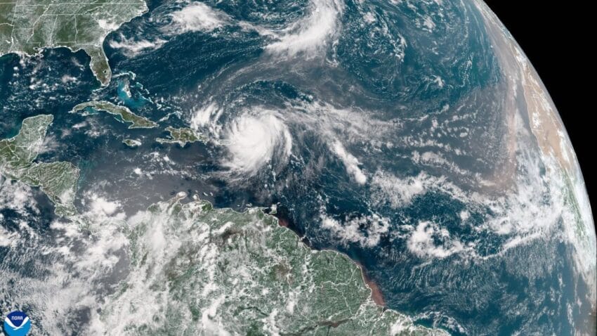
rapidly intensifying hurricane erin becomes historic storm — Hurricane Erin has rapidly intensified into a historic Category 5 storm, marking a significant event in this year's hurricane season..
Rapidly Intensifying Hurricane Erin Becomes Historic Storm
Hurricane Erin has rapidly intensified into a historic Category 5 storm, marking a significant event in this year’s hurricane season.
Hurricane Erin’s Rapid Intensification
Hurricane Erin has made headlines recently due to its rapid intensification, becoming a Category 5 storm, the highest classification for hurricanes. This event is particularly noteworthy as it sets a record for early-season intensification, occurring during a time when hurricane activity is typically just beginning to ramp up.
After several days traversing the open and often challenging conditions of the Atlantic Ocean, Erin experienced a dramatic increase in intensity on Friday night. By midday Saturday, the National Hurricane Center officially classified Erin as a Category 5 hurricane. This classification is based on sustained wind speeds that were recorded by a U.S. Air Force Hurricane Hunter aircraft.
Wind Speeds and Measurements
The storm’s classification as a Category 5 is based on impressive wind speeds measured at an astonishing 160 mph. This level of intensity showcases the storm’s significant power and potential for destruction. The rapid intensification of Erin is a reminder of the unpredictable nature of hurricanes, which can escalate quickly under the right atmospheric conditions.
Category 5 hurricanes are characterized by their extreme wind speeds, which can cause catastrophic damage to structures, trees, and infrastructure. The implications of such a storm are severe, as areas in the path of a Category 5 hurricane face the risk of total destruction. The measurement of wind speeds is crucial, as it helps meteorologists and emergency management officials assess the potential impact of the storm.
Projected Path and Impact
While the intensity of Hurricane Erin poses a serious threat, there is some positive news regarding its projected path. Current forecasts indicate that Erin will navigate through a narrow corridor, passing close to several landmasses over the next week. However, it is anticipated that the storm will maintain a safe distance from these areas, thereby reducing the risk of catastrophic damage.
- Erin is currently situated north of the Caribbean islands.
- The storm is expected to turn northward before reaching the Bahamas.
- Later next week, Erin’s path will likely take it between Atlantic Canada and Bermuda.
The projected path of Hurricane Erin is critical for residents and officials in the potential impact zones. While the storm is currently expected to avoid direct landfall, the situation can change rapidly. Meteorologists will continue to monitor Erin’s trajectory closely, providing updates as new data becomes available.
Historical Context of Hurricane Intensity
The rapid intensification of Hurricane Erin is not an isolated event but rather part of a broader trend observed in recent years. Climate scientists have noted an increase in the frequency and intensity of hurricanes, particularly in the Atlantic basin. This trend raises concerns about the potential impacts of climate change on hurricane behavior.
Historically, hurricanes have been categorized based on the Saffir-Simpson Hurricane Wind Scale, which classifies storms from Category 1 (minimal damage) to Category 5 (catastrophic damage). The increase in Category 4 and 5 storms in recent years suggests a shift in hurricane dynamics, which could be influenced by warmer ocean temperatures and changing atmospheric conditions.
Implications for Residents and Emergency Management
The implications of Hurricane Erin’s rapid intensification are significant for residents in the projected path of the storm. Emergency management officials are urging residents to stay informed and prepared for any changes in the storm’s path or intensity. This includes having emergency kits ready, understanding evacuation routes, and staying tuned to local news and weather updates.
Preparedness is key when dealing with hurricanes, especially those that have the potential for rapid intensification. Communities in hurricane-prone areas are encouraged to participate in preparedness drills and to have plans in place for various scenarios, including potential evacuations.
The Role of Technology in Hurricane Tracking
Advancements in technology have significantly improved our ability to track and predict hurricanes. The use of satellite imagery, radar systems, and aerial reconnaissance by the U.S. Air Force has enhanced the accuracy of storm forecasts. These technologies allow meteorologists to monitor changes in storm intensity and trajectory in real-time, providing critical information to emergency management officials and the public.
As Hurricane Erin continues to develop, it serves as a reminder of the importance of monitoring hurricane activity closely. The unpredictable nature of these storms necessitates constant vigilance and preparedness, particularly for those living in coastal regions.
Conclusion
In conclusion, Hurricane Erin’s rapid intensification into a Category 5 storm marks a significant event in this year’s hurricane season. While the storm poses a serious threat, current forecasts suggest it may navigate through a narrow corridor, potentially avoiding direct landfall on populated areas. However, the unpredictable nature of hurricanes means that residents in the potential impact zones should remain vigilant and prepared for any changes in the storm’s path or intensity.
As we continue to observe Hurricane Erin’s development, it is crucial for communities to prioritize preparedness and stay informed through reliable sources. The increasing frequency of intense hurricanes underscores the need for ongoing research and investment in technology to enhance our understanding and response to these powerful storms.
Source: Original reporting
Further reading: related insights.
Further reading: related insights.
Further reading: related insights.
Was this helpful?
Last Modified: August 17, 2025 at 2:33 pm
1 views


